Geography MCQ Quiz - Objective Question with Answer for Geography - Download Free PDF
Last updated on Jun 3, 2026
Latest Geography MCQ Objective Questions
Geography Question 1:
Satellite navigation systems have become increasingly relevant in transport, rescue operations, intelligence movement, logistics, survey work, and field-level coordination. A candidate should be able to identify GPS in functional terms rather than by memorizing only its expansion. Which of the following options best represents the principal purpose of GPS?
Answer (Detailed Solution Below)

Geography Question 1 Detailed Solution
The correct answer is It provides location, navigation, route guidance, tracking, and timing information using satellite signals.
 Key Points
- GPS (Global Positioning System) is a satellite-based navigation system that provides precise location and timing information to users worldwide.
- The primary function of GPS is to assist in location determination, route navigation, and tracking across various fields like transport, logistics, and rescue operations.
- It works by using signals from a network of satellites orbiting the Earth to pinpoint the exact position of a receiver on the ground.
- GPS is also widely used in timing synchronization, which is critical for operations like telecommunications, power grids, and financial transactions.
- The versatility of GPS makes it an integral tool in field-level coordination for activities like surveying, mapping, and military intelligence.
- Hence, the correct option is "It provides location, navigation, route guidance, tracking, and timing information using satellite signals."
 Additional Information
- Characteristics and Functionality of GPS:
- GPS is operated by the United States Department of Defense but is freely accessible to anyone with a GPS receiver.
- It comprises a constellation of at least 24 satellites in medium Earth orbit, providing global coverage.
- GPS is based on the principle of trilateration, where signals from at least three satellites are used to calculate the receiver's position.
- Applications of GPS:
- Transport: Used for vehicle navigation, fleet management, and optimizing delivery routes.
- Rescue Operations: Helps locate individuals in emergencies, such as during natural disasters or accidents.
- Surveying and Mapping: Enables precise data collection for land surveying, urban planning, and resource management.
- Military Applications: Used for troop movement, missile guidance, and secure communication.
- Everyday Use: Found in smartphones, smartwatches, and fitness trackers for personal navigation and activity tracking.
- Global Navigation Satellite Systems (GNSS):
- Other countries have developed their own satellite navigation systems, like GLONASS (Russia), Galileo (European Union), and BeiDou (China).
- India's NAVIC (Navigation with Indian Constellation) is a regional navigation satellite system designed to provide accurate positioning in India and surrounding areas.
 Important Points
- Debunking Incorrect Options:
- Option 1: GPS is not used to predict earthquakes. Seismology relies on other technologies like seismometers and geophones.
- Option 2: GPS is not designed to encrypt military communication. Communication encryption is handled by specialized systems like secure satellite networks.
- Option 3: GPS is unrelated to weather control. Weather modification technologies like cloud seeding are used for artificial rainfall.
- Advantages of GPS:
- Highly accurate and reliable for global navigation.
- Supports a wide range of industries, from aviation to agriculture.
- Provides real-time tracking for security and monitoring purposes.
Geography Question 2:
In security operations, civilian navigation, disaster response, fleet management, and field-level movement control, satellite-based positioning systems have become extremely important. Examinations often test whether the candidate can identify the principal function of GPS rather than merely expanding the abbreviation. Which of the following best states the main use of GPS in practical terms?
Answer (Detailed Solution Below)
Geography Question 2 Detailed Solution
The correct answer is It enables location determination, route navigation, tracking, and time-based positioning services through satellite signals.
Key Points
- Global Positioning System (GPS): GPS is a satellite-based navigation system that provides geolocation and time information to a GPS receiver anywhere on or near the Earth.
- It is widely used for location determination, route navigation, tracking, and time synchronization in various fields like transportation, military operations, disaster management, and civilian navigation. Hence, option 3 is correct.
- The GPS system operates through a network of satellites and ground stations, enabling precise tracking and positioning globally. This makes it an integral tool in modern-day logistics and mobility.Hence, the statement in the question is valid and correct.
- Other options like gene sequencing (Option 1), analog-to-digital conversion (Option 2), and weather control systems (Option 4) do not pertain to the core function of GPS. These options are unrelated to satellite navigation systems, making them incorrect.
Additional Information
- Key Features of GPS:
- GPS is a satellite-based navigation system developed by the United States Department of Defense in 1973. It became available for civilian use in the 1980s.
- The system consists of a constellation of 24 operational satellites (with backups) orbiting the Earth at an altitude of approximately 20,200 km.
- GPS provides services like real-time positioning, timing synchronization, and route optimization, which are crucial for industries like aviation, shipping, and telecommunications.
- Applications of GPS:
- In transportation, GPS is used for navigation, fleet management, and real-time vehicle tracking.
- In disaster response, it aids in locating affected areas, planning rescue operations, and managing resources efficiently.
- In military operations, it is critical for mission planning, troop movements, and precision strikes.
- In civilian navigation, GPS is widely used in smartphones, wearable devices, and car navigation systems for route optimization and location tracking.
- Comparison of Options:
- Option 1: Gene sequencing is a biological process unrelated to satellite navigation.
- Option 2: Analog-to-digital conversion involves data transformation and is unrelated to GPS functionalities.
- Option 4: Weather control systems are hypothetical and not associated with GPS technology.
Important Points
- GPS vs Other Navigation Systems:
- GLONASS: Russia’s equivalent of GPS, operational since the mid-1990s.
- Galileo: The European Union’s satellite navigation system, providing global services since 2016.
- BeiDou: China’s navigation system providing coverage since 2000, with global services since 2020.
- Future of GPS:
- Upgrades in GPS technology include increased accuracy, improved anti-jamming capabilities, and better integration with other satellite systems.
Geography Question 3:
Remote sensing has become indispensable for disaster management, border monitoring, agricultural assessment, water-resource mapping, forest surveys, urban planning, and land-use analysis. Yet many candidates confuse it with ordinary field inspection or communication transmission. Which of the following best defines remote sensing in scientific and administrative application?
Answer (Detailed Solution Below)
Geography Question 3 Detailed Solution
The correct answer is It is the technique of collecting information about the Earth’s surface from a distance, typically through satellite or airborne sensors without direct physical contact.
Key Points
- Definition of Remote Sensing: Remote sensing refers to the scientific technique of collecting data and information about the Earth's surface without being in direct contact with it. This is primarily achieved using satellite-based or airborne sensors.
- The process involves the detection and measurement of reflected or emitted electromagnetic radiation from the Earth's surface, which is then analyzed to gather insights about natural and man-made phenomena. Hence, the statement is correct.
- Applications of Remote Sensing: It plays a crucial role in disaster management, agricultural assessment, water-resource mapping, forest surveys, urban planning, and land-use analysis. These tasks require precise and large-scale data collection, which is best achieved through remote sensing. This aligns with the question context.
- Unlike ordinary field inspections, remote sensing does not involve physical contact with the area being studied. Instead, it relies on advanced sensors and technology to collect data from a distance. Hence, statement 1 is correct.
- The other options do not describe remote sensing accurately. For instance, Option 2 refers to field inspection, Option 3 mentions communication transmission, and Option 4 describes geological drilling. None of these align with the scientific and administrative applications of remote sensing. Therefore, these options are incorrect.
- Hence, the correct answer is It is the technique of collecting information about the Earth’s surface from a distance, typically through satellite or airborne sensors without direct physical contact.
Additional Information
- Key Components of Remote Sensing:
- Source of Energy: Remote sensing utilizes natural sources like sunlight (passive sensors) or artificial sources like lasers (active sensors) to collect data.
- Platform: Data collection platforms include satellites, drones, or aircraft. These platforms carry sensors capable of capturing high-resolution images and other data.
- Sensors: Sensors like optical, infrared, and microwave sensors detect and measure electromagnetic radiation reflected from or emitted by Earth's surface.
- Applications of Remote Sensing:
- Disaster Management: Remote sensing helps in monitoring natural disasters like earthquakes, floods, and tsunamis, enabling quick response and recovery efforts.
- Agricultural Monitoring: It is used to analyze crop health, predict yields, and monitor irrigation practices.
- Urban Planning: Helps planners in land-use analysis, city expansion monitoring, and infrastructure development.
- Forestry: Remote sensing is vital for tracking deforestation, assessing forest health, and mapping biodiversity.
- Examples of Remote Sensing Satellites:
- Landsat Program: A joint initiative by NASA and the United States Geological Survey (USGS), providing long-term data for Earth's surface studies.
- Sentinel Satellites: Part of the European Space Agency’s Copernicus program, these satellites monitor environmental changes and natural disasters.
- IRS Series: The Indian Remote Sensing (IRS) satellites are used for land mapping, disaster management, and resource monitoring.
Important Points
- Difference between Remote Sensing and Field Inspection:
- Remote sensing collects data over large areas without physical contact, whereas field inspections involve on-ground visits and direct observation.
- Field inspections are labor-intensive and time-consuming, while remote sensing is efficient, scalable, and provides frequent data updates.
- Limitations of Remote Sensing:
- It requires specialized technology and expertise for data analysis.
- Cloud cover and atmospheric conditions can affect data quality and sensor performance.
Geography Question 4:
Which of the following is not a UNESCO ‘s site in India related to Buddhism?
Answer (Detailed Solution Below)
Geography Question 4 Detailed Solution
The correct answer is - Khajuraho group of monuments, Madhya Pradesh
Key Points
- Khajuraho group of monuments
- The Khajuraho group of monuments in Madhya Pradesh is a UNESCO World Heritage Site, but it is not related to Buddhism.
- These monuments are primarily known for their Hindu and Jain temples, with intricate sculptures depicting various themes of Indian life and spirituality.
- Other options
- The Archaeological Site of Nalanda Mahavira at Nalanda (Bihar) is directly associated with Buddhism and is a UNESCO World Heritage Site.
- The Mahabodhi Temple Complex at Bodh Gaya (Bihar) is a revered site for Buddhists as it marks the place where Gautama Buddha attained enlightenment.
- The Ajanta Caves in Aurangabad, Maharashtra, are famous for their Buddhist rock-cut architecture, paintings, and sculptures.
Additional Information
- UNESCO World Heritage Sites in India related to Buddhism
- Mahabodhi Temple Complex at Bodh Gaya (Bihar): Built at the location of Buddha's enlightenment.
- Archaeological Site of Nalanda Mahavihara (Bihar): An ancient center for Buddhist learning and a monastery.
- Ajanta Caves (Maharashtra): Known for their Buddhist monasteries and exquisite paintings from the Gupta period.
- Sanchi Stupa (Madhya Pradesh): A key monument of Buddhist architecture.
- Khajuraho group of monuments
- These monuments consist of Hindu and Jain temples constructed between the 9th and 11th centuries by the Chandela dynasty.
- They are renowned for their erotic sculptures, rich art, and architecture, but they have no direct link to Buddhism.
Geography Question 5:
Ace, Advantage, Deuce and Half volley are some of the terms associated with which sport?
Answer (Detailed Solution Below)
Geography Question 5 Detailed Solution
The correct answer is Lawn Tennis.
Key Points
- Lawn Tennis is a racket sport that can be played individually against a single opponent (singles) or between two teams of two players each (doubles). The terms mentioned in the question are foundational to the scoring and technical aspects of this sport.
- Ace: This refers to a legal serve that is not touched by the receiver's racket, resulting in an immediate point for the server. It is one of the most effective ways to win a point in professional matches, especially on fast surfaces like grass.
- Deuce: This term is used when the score in a game is tied at 40-40. According to the rules of Lawn Tennis, a game must be won by a margin of at least two points. When deuce is reached, play continues until one player wins two consecutive points.
- Advantage: This follows a deuce. The player who wins the next point after deuce is said to have the advantage. If the server wins the point, it is called Advantage In (Ad-in); if the receiver wins, it is Advantage Out (Ad-out). If the player with the advantage loses the next point, the score returns to deuce.
- Half Volley: This is a technical tennis shot where the player hits the ball immediately after it bounces on the court, usually while the ball is still very low. It requires excellent timing and reflexes as it is often played near the baseline or while approaching the net.
- The modern game of Lawn Tennis originated in Birmingham, England, in the late 19th century. It was pioneered by Major Walter Clopton Wingfield, who patented the game in 1873.
Additional Information
- Grand Slam Tournaments: These are the four most prestigious annual events in Lawn Tennis, organized by the International Tennis Federation (ITF).
- Australian Open: Played on Hard Courts in Melbourne during January.
- French Open (Roland Garros): Played on Clay Courts in Paris during May-June.
- Wimbledon: The oldest tennis tournament, played on Grass Courts in London during June-July.
- US Open: Played on Hard Courts in New York during August-September.
- Scoring System: The unique scoring system of tennis uses the terms Love (0), 15, 30, and 40. The term Love is believed to be derived from the French word l'oeuf, meaning egg, symbolizing the shape of a zero.
- Terms associated with other options:
- Golf: Common terms include Birdie (one stroke under par), Eagle (two strokes under par), Bogey (one stroke over par), Putter, Tee, and Fairway.
- Polo: Key terms include Chukka (a period of play lasting 7.5 minutes), Mallet (the stick used to hit the ball), and Hooking.
- Wrestling: Common terms include Half Nelson, Heave, Reversal, Takedown, and Pinfall.
- Governing Body: The International Tennis Federation (ITF) is the world governing body of tennis, overseeing Davis Cup, Billie Jean King Cup, and the Olympic tennis event. It was founded in 1913 as the International Lawn Tennis Federation.
Important Points
- The term Advantage is only applicable in games using the standard scoring format; some modern formats like Fast4 Tennis or No-Ad scoring eliminate the advantage point to speed up the game.
- In Lawn Tennis, a set is typically won by the first player to reach 6 games with a lead of at least 2 games. If the set reaches 6-6, a tie-break is usually played to determine the winner.
- Famous players who have mastered these techniques include Roger Federer, Rafael Nadal, Novak Djokovic, and Serena Williams, who collectively hold numerous Major titles.
Top Geography MCQ Objective Questions
India accounts for how much of total world’s surface area?
Answer (Detailed Solution Below)
Geography Question 6 Detailed Solution
Download Solution PDFThe correct answer is 2.4
Key Points
- India accounts for about 2.4 percent of the total surface area of the world.
- India has an area of 32,87,263 sq. km making it the seventh-largest country of the world.
- The east to west width from the Rann of Kutch to Arunachal Pradesh is 2,933 km.
- The north to south extent of India from Indira Col in Kashmir to Kanyakumari is 3,214 km.
- The southernmost point of the country is the Pygmalion Point or Indira Point located at 6 deg. 45 inches North latitude.
- The Tropic of Cancer passes through the middle of the country dividing it into two latitudinal halves.
Additional Information
- The countries that are larger than India are as follows-
- Russia
- Canada
- China
- U.S.A.
- Brazil
- Australia
Which of the following is the closest layer to the Earth's surface in which all weather occurs?
Answer (Detailed Solution Below)
Geography Question 7 Detailed Solution
Download Solution PDFThe correct answer is Troposphere.
Key Points
- The troposphere is the lowest part of the Earth's atmosphere in which all tropical changes take place.
- It contains about 75% of the total air in the atmosphere.
- Based on temperature variation, our atmosphere can be classified into the following layers mainly.
- Troposphere: From Earth's surface up to 10km. Here, temperature decreases with increasing height. We, humans, live in the troposphere, and nearly all weather occurs in this lowest layer. Most clouds appear here.
- Stratosphere: From 10km above the surface to 50km above the surface, Here, temperature increases with increasing height due to the presence of the ozone layer.
- Ozone gas is capable of absorbing harmful UV rays and due to the absorption, the temperature increases.
- All the airplanes fly in this zone as due to high temperature there is less turbulence and hence smoother flights are possible.
- Mesosphere: From 50km above the surface to 85 km above the surface. Here, the temperature again decreases with increasing height. Most meteors burn up in the mesosphere.
- Ionosphere: Beyond 85km there is a thermosphere layer and Ionosphere is a series of regions in parts of the mesosphere and thermosphere.
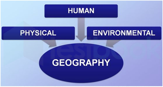
Which one of the following scholars coined the term ‘Geography’?
Answer (Detailed Solution Below)
Geography Question 8 Detailed Solution
Download Solution PDFThe correct answer is Erathosthenese.
Key Points
- The term ‘Geography’ was first coined by Eratosthenes.
- It is the combination of two Greek words, Geo (the earth) and Graphos (to write).
- Geography is the study of the Earth’s landscapes, peoples, places and environments.
- Physical Geography is the study of natural things like Volcanoes, earthquakes; rivers, oceans, glaciers; soil, water, air; weather and climate etc.
- Human Geography is the study of people, settlements, transport, industry etc.
- It examines how humans adapt themselves to the land and to other people, and in macroscopic transformations, they enact on the world.
- Environmental Geography is the combination of Physical and Human geography.

Additional Information
- Herodotus: Herodotus is known as the “Father of History.” and is well known for his historical accounts.
- Galileo: He was an Italian scientist and scholar whose inventions included the telescope.
- His discoveries laid the foundation for modern physics and astronomy.
- Aristotle: He was an Ancient Greek philosopher and scientist and his works are in fields of politics, psychology and ethics.
Which of the following is NOT a desert in India?
Answer (Detailed Solution Below)
Geography Question 9 Detailed Solution
Download Solution PDFThe correct answer is the Indus valley desert.
Key Points
- The Indus Valley Desert is an almost uninhabited desert ecoregion of northern Pakistan.
- It covers an area of 19,501 sq km in northwestern Punjab Province between the Chenab and Indus rivers.
- It is drier and less hospitable than the northwestern thorn scrub forests that surround it with temperatures ranging from freezing in winter to extremely hot in summer with only 600-800 mm of rainfall per year.
- The desert is home to five large mammals: Indian wolf, striped hyena, caracal, Indian leopard, and the urial along with many rodents and other mammals.
Additional Information
- The Thar desert
- The Thar Desert is located in India (Rajasthan) and is also known as the Great Indian Desert.
- The Thar Desert extends between the Aravalli Hills in the northeast and the Rann of Kutch in the west and the alluvial plains of the Indus River in the northwest.
- It is located partly in the Rajasthan state of India and partly in the Punjab and Sindh provinces of Pakistan.
- Rann of Kutch
- The Great Rann of Kutch is a salt marsh in the Thar Desert in the Kutch District of Gujarat.
- It is divided into the Great Rann and Little Rann.
- The history of the Rann of Kutch began with early neolithic settlements. It was later inhabited by the Indus Valley Civilization as well as the Maurya and Gupta empires of India.
- Spiti valley cold desert
- Spiti Valley is a cold desert mountain valley located high in the Himalayas in the northeastern part of the northern Indian state of Himachal Pradesh.
- The name "Spiti" means "The middle land" i.e. the land between Tibet and India.
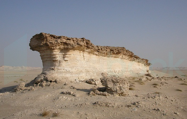
Which landform is produced by wind erosion?
Answer (Detailed Solution Below)
Geography Question 10 Detailed Solution
Download Solution PDFThe correct answer is Zeugen.
Key Points
- Zeugen landform is produced by wind erosion.
- Zeugen:
- It is table shaped landform.
- Mostly seen in arid and semi-arid regions.
- The softer part of the rock is eroded by wind and the harder part remains as it is.
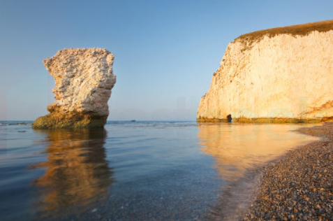
Additional Information
- Cirque:
- Cirques are formed by glacier erosion.
- Cirques are amphitheater-shaped valleys with precipitous walls.
- Stacks:
- Stacks are formed by coastal wind and water waves.
- Generally seen in coastal areas.
- The formation of Stacks takes a very long time.
Which one of the following disciplines attempts temporal synthesis?
Answer (Detailed Solution Below)
Geography Question 11 Detailed Solution
Download Solution PDFcorrect answer is History.The
Key Points
- Temporal synthesis is defined as the automated construction of a system whereby we develop a temporary specification and then try to prove it.
- It is done in history as a discipline.
- It refers to the comparisons made with respect to the passage of time.
- Here, if a process is temporally extended, it means that it happens over a period of time.
- If the occurrence of two events differs temporally, then they happened at different points in time.
Additional Information
- Spatial synthesis is attempted by Geography.
- It includes any of the formal techniques which study entities using their topological, geometric, or geographic properties.
In which year was Golghar constructed in Patna?
Answer (Detailed Solution Below)
Geography Question 12 Detailed Solution
Download Solution PDF1786 is correct answer.Key Points
- Captain John Garstin erected Golghar, an enormous granary, for the British army in 1786, following the devastation of the 1770 famine. The winding stairway encircling this monument provides a spectacular perspective over the city and the neighboring Ganga.
- It was constructed in 1786. It was constructed at the request of the then-owner, Warren Hastings.
- In 1770, Bihar had severe draught, resulting in a serious food shortage. Concerned about the people's situation, the British soldiers built this large granary.
- The structure is 29 meters tall and built in the Stupa style. It has no pillars and a 3.6 m thick wall at the base.
- The 145-step spiral stairway leads to the top of the Golghar. The spiral staircase was built to help the workers who loaded and unloaded grain in the granary, who had to carry grain-bags up one flight and deliver their load through a door.
Additional Information
- During the famine, India, which was under British rule at the time, faced a lot of trouble when the then-governor general of the country, Warren Hastings, ordered the construction of a building to store grains and other food items only for the British people and not for the suffering Indians.
- The building, which has a spherical appearance from the exterior, has no pillars and is unique in that it can store around 1,40,000 tons of grains.
- The building's interior features a spiral staircase that leads all the way to the top.
- The whole apparatus was created such that the persons obtaining the grains from the top could simply throw it out the top hole, and the substance would securely drop downstairs.
Which of the following is a type of precipitation?
Answer (Detailed Solution Below)
Geography Question 13 Detailed Solution
Download Solution PDFThe Correct Answer is Hail.
Key Points
- Hail:
- Hail is a form of precipitation that consists of solid ice that forms inside thunderstorm updrafts.
- It occurs when water droplets are carried upward by the storm's updraft into extremely cold areas of the atmosphere and freeze into ice.
- Hailstones can grow by colliding with supercooled water droplets that freeze upon contact, becoming larger before falling to the ground.
- This makes hail a clear example of precipitation, as it involves water falling from the sky in a solid form.
- Bala:
- The term "Bala" does not refer to any known form of precipitation or weather phenomenon.
- It might be a typo or an incorrect entry, as it doesn't relate to meteorological terms or concepts.
- Fog:
- Fog is not a type of precipitation but rather a cloud that forms at the ground level.
- It occurs when the air near the ground cools enough to turn its water vapor into liquid water droplets, creating a thick mist.
- While it involves water in the atmosphere, it does not involve water falling to the ground, which is a key characteristic of precipitation.
- Haze:
- Haze is a slight obscuration of the lower atmosphere, typically caused by particles and pollutants in the air such as dust, smoke, and other particulate matter.
- Unlike fog, haze does not consist of water droplets but rather of dry particles that reduce visibility.
- It is not a form of precipitation since it does not involve water falling from the atmosphere to the ground.
Which of the following is the outermost layer of the atmosphere?
Answer (Detailed Solution Below)
Geography Question 14 Detailed Solution
Download Solution PDFThe correct answer is Mesosphere.
Key Points
- The mesosphere is the outermost layer of the atmosphere among these all options.
- Among all layers of the earth's atmosphere Exosphere is the outermost layer.
- The mesosphere is the third layer of the atmosphere, directly above the stratosphere and directly below the thermosphere.
- In the mesosphere, temperature decreases as altitude increases.
Image: 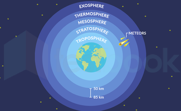
Important Points
- The Ozone layer is in Stratosphere.
- Planes generally fly in Stratosphere.
- The stratosphere is about 5 kilometres from the ground.
Additional Information
- The asthenosphere is the highly viscous, mechanically weak, and ductile region of the upper mantle of Earth.
- The lithosphere is the rocky outer part of the Earth.
- The troposphere is the bottom-most layer of the Earth's atmosphere.
The metallic minerals that occur as alluvial deposits in flood plains or valleys are known as _______.
Answer (Detailed Solution Below)
Geography Question 15 Detailed Solution
Download Solution PDFThe correct answer is placer deposits.
Key Points
- Placer deposits, or "placers," are collections of valuable minerals that have been naturally concentrated in overburden, stream sediments, or beach materials.
- The minerals are liberated from solid rock by mechanical and chemical weathering.
- Then they are typically carried to their final resting place by water or wind action.
- Large minerals or minerals with a higher density are deposited when the water's velocity slows.
- Heavy minerals, such as gold, diamond, Ti, Cr, Sn, and magnetite, will be concentrated in locations where water current velocity is low because they will be deposited at a faster rate than low density minerals, such as quartz.
- Placer deposits have a specific gravity above 2.58.
Additional Information
- Polymetallic nodules:
- Manganese nodules, also known as polymetallic nodules, are mineral concretions on the ocean floor that are made of a central core and concentric layers of iron and manganese hydroxides.
- They contain four essential battery metals: cobalt, nickel, copper and manganese, in a single ore.
- Vein deposits:
- Veins are mineral deposits that develop when fresh mineral material fills a pre-existing fissure or crack inside a host rock. Aqueous solutions are often circulated to perform mineral deposition.
